Örtliche Rundwanderwege an der Römischen Weinstraße 22 örtliche Rundwanderwege mit einer Länge von ca. 250 km verbinden die verschiedenen Ortschaften und Sehenswürdigkeiten miteinander.
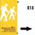
Neben Wegweisern, die mit Entfernungs- und Zielangaben versehen sind,
werden einheitliche Markierungszeichen eingesetzt, mit denen die Wege
grundsätzlich in beide Richtungen markiert werden.
R1 Schweich – Föhren – Naurath – Föhren – Schweich 19,0 km Dieser Inhalt wird abhängig von Ihren Privatsphäreneinstellungen dargestellt und erfordert daher JavaScript R2 Kenn - Biotop Ackersberg - Kenn 6,3 km Dieser Inhalt wird abhängig von Ihren Privatsphäreneinstellungen dargestellt und erfordert daher JavaScript R3 Schweich – Bekond – Landwehrkreuz – Schweich 14,8 km Dieser Inhalt wird abhängig von Ihren Privatsphäreneinstellungen dargestellt und erfordert daher JavaScript R4 Longen – Longuicher Brücke – Rupperoth – Longen 9,2 km Dieser Inhalt wird abhängig von Ihren Privatsphäreneinstellungen dargestellt und erfordert daher JavaScript R5 Mehring - Sauerbrunnen Mehring - Hundsbuckel - Huxlay-Plateau - Mehring 9,8 km Dieser Inhalt wird abhängig von Ihren Privatsphäreneinstellungen dargestellt und erfordert daher JavaScript R6 Bekond - Ensch – Zitronenkrämerkreuz - Hummelsberg - Grillhütte Bekond - Bekond 11,8 km Dieser Inhalt wird abhängig von Ihren Privatsphäreneinstellungen dargestellt und erfordert daher JavaScript R7 Schleich - Pölich - Ensch - Schleich 10,5 km Dieser Inhalt wird abhängig von Ihren Privatsphäreneinstellungen dargestellt und erfordert daher JavaScript R8 Bekond - Thörnicher Ritsch - Bekond 8,8 km Dieser Inhalt wird abhängig von Ihren Privatsphäreneinstellungen dargestellt und erfordert daher JavaScript R9 Klüsserath - Trittenheim - Klüsserath 14,9 km Dieser Inhalt wird abhängig von Ihren Privatsphäreneinstellungen dargestellt und erfordert daher JavaScript R10 Kenn - Longuich-Kirsch - Sang-Neuhaus - Kenn 10,8 km Dieser Inhalt wird abhängig von Ihren Privatsphäreneinstellungen dargestellt und erfordert daher JavaScript R11 Kirsch - Sang Neuhaus - Villa Urbana - Longuich - Kirsch 9,7 km Dieser Inhalt wird abhängig von Ihren Privatsphäreneinstellungen dargestellt und erfordert daher JavaScript R12 Riol - Fell - Fastrau - Riol 9,1 km Dieser Inhalt wird abhängig von Ihren Privatsphäreneinstellungen dargestellt und erfordert daher JavaScript R13 Fell - Besucherbergwerk Fell - Fellerhof - Fell 10,3 km Dieser Inhalt wird abhängig von Ihren Privatsphäreneinstellungen dargestellt und erfordert daher JavaScript R14 Klettersteig Riol/Mehring, Einstieg Molesbachmündung 2,9 km Dieser Inhalt wird abhängig von Ihren Privatsphäreneinstellungen dargestellt und erfordert daher JavaScript R15 Villa Rustica Mehring - Mehringer Schweiz - Villa Rustica Mehring 8,3 km Dieser Inhalt wird abhängig von Ihren Privatsphäreneinstellungen dargestellt und erfordert daher JavaScript R16 Detzem - Fünf-Seen-Blick - Detzem 14,9 km Dieser Inhalt wird abhängig von Ihren Privatsphäreneinstellungen dargestellt und erfordert daher JavaScript R17 Thörnich - Detzem - Leiwen - Köwerich - Thörnich 10,2 km Dieser Inhalt wird abhängig von Ihren Privatsphäreneinstellungen dargestellt und erfordert daher JavaScript R18 Leiwen – Fünf-Seen-Blick – Zummethöhe – Leiwen 15,6 km Dieser Inhalt wird abhängig von Ihren Privatsphäreneinstellungen dargestellt und erfordert daher JavaScript R19 Trittenheim - Zummethöhe Leiwen - Grillhütte Trittenheim- Trittenheim 5,3 km Dieser Inhalt wird abhängig von Ihren Privatsphäreneinstellungen dargestellt und erfordert daher JavaScript RW9 "Rund ums Dhrönchen": Zummethöhe – Dhrönchen – Heidenburg –Papiermühle – Reiterhof Kron – Zummethöhe 13,8 km Dieser Inhalt wird abhängig von Ihren Privatsphäreneinstellungen dargestellt und erfordert daher JavaScript RW10 "Kroner Rundweg": Zummethöhe – Vogelsang – Reiterhof Kron – Zummethöhe 6,4 km Dieser Inhalt wird abhängig von Ihren Privatsphäreneinstellungen dargestellt und erfordert daher JavaScript RW11 Trittenheim – Hinkelstein – Schützenhaus Neumagen – Judenfriedhof Trittenheim - Trittenheim 16,5 km Dieser Inhalt wird abhängig von Ihren Privatsphäreneinstellungen dargestellt und erfordert daher JavaScript
digitale Karte Unsere interaktive Karte liefert wichtige Informationen zur Planung von Wanderungen. Klicken Sie einfach auf die Karte! >hier geht es zur Karte
Wanderkarten Hier können Sie aktuelle Wanderkarten online gegen Rechnung für 7,90 € bestellen.
>Kartenbestellung
Touren App
Wer in Rheinland-Pfalz auf Wander- oder Radwegen unterwegs ist, hat mit der kostenlosen Touren-App Rheinland-Pfalz einen zuverlässigen Begleiter bzw. kann diese für die Touren-planung vorab nutzen.
Dieser Inhalt wird abhängig von Ihren Privatsphäreneinstellungen dargestellt und erfordert daher JavaScript 

